|
|
||
|
Tiverton Township, Coshocton County, Ohio |
||

![]() Wooster
Daily Record Article 9/10/00
Wooster
Daily Record Article 9/10/00
![]() Cleveland
Plain Dealer Article 9/29/00
Cleveland
Plain Dealer Article 9/29/00
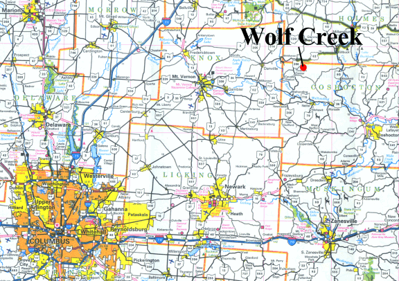
Directions to Wolf Creek & Ohio Outdoor Experience
From Downtown and East Side of Columbus: Take State Route 62 to Danville (approximately 1 hr. from downtown Columbus). Follow S.R. 62 another 7 miles until you reach S.R. 206. Turn right on S.R. 206 (south) and travel 1.8 miles until you see the large "Pilgrim Hills" sign. Turn left (east) at the sign onto Township Road 351 and go to the bottom of the hill (approx. 1 mile). You will see an Ohio Outdoor Experience sign on the right side of the road when you reach the property. Turn right at the sign and park in the small gravel parking lot (just past the vacant white farmhouse).
From the North side of Columbus: Take S.R. 3 into Mt. Vernon. Follow Rt. 36 east out of Mt. Vernon approximately 13 miles to S.R. 62. Turn left on 62 and travel approximately 7 miles to Danville. Follow S.R. 62 another 7 miles until you reach S.R. 206 (approximately 5 miles past Danville). Turn right on S.R. 206 (south) and travel 1.8 miles until you see the large "Pilgrim Hills" sign. Turn left (east) at the sign onto Township Road 351 and go to the bottom of the hill (approx. 1 mile). You will see an Ohio Outdoor Experience sign on the right side of the road when you reach the property. Turn right at the sign and park in the small gravel parking lot (just past the vacant white farmhouse).
From Cleveland: Take I-71 to S.R. 83 (exit 204). Head south on 83 approximately 35 miles (passing through Wooster & Holmesville) until you reach Millersburg. S.R. 62 joins S.R. 83 in Millersburg. Continue south on S.R. 83 another three miles past Millersburg. S.R. 62 will veer off to the right. Follow S.R. 62 16 miles until you reach S.R. 206. Turn left (south) and travel 1.8 miles until you see the large "Pilgrim Hills" sign. Turn left (east) at the sign onto Township Road 351 and go to the bottom of the hill (approx. 1 mile). You will see our sign on the right side of the road when you reach the property. Turn right at the sign and park in the small gravel parking lot (just past the vacant white farmhouse).
From Akron/Canton: Take State Route 62 to the intersection of SR 62 and State Route 206. This intersection is approximately 50 miles southwest of Canton. Turn left on State Route 206 (you will be traveling southbound) and travel 1.8 miles until you see the large "Pilgrim Hills" sign. Turn left (east) at the sign onto Township Road 351 and go to the bottom of the hill (approx. 1 mile). You will see our sign on the right side of the road when you reach the property. Turn right at the sign and park in the small gravel parking lot (just past the vacant white farmhouse).